Working pretty much non-stop on getting stuff ready for the season. Will be definately writing two big posts on both the Dry Valleys and the DryVER project over the next few days.
Heres what I was working on yesterday for the UC climate team. A single tripod mount holding a five band Micasense Rededge multispectral camera and an Optix thermal imaging camera. This system will capture through the visible spectrum into near infra red and then into far infra red.
Surprisingly, given my tiny monkey like hands, and terrible engineering skills it actually came out allright!
Wednesday, 23 December 2015
Tuesday, 15 December 2015
Gah
Sunday, 13 December 2015
More Sony QX100 nonsense
Over the last week I have finally had a chance to work on adding a second mapping camera to the Solo drone. We went with the Sony as it was lightweight and used by Draganfly as one of their main multirotor cameras. I wasnt 100% sure about the model but after a bit of playing with it, its pretty cool.
Holy crap its light. I ordered a Imp-Concepts accessory bay mounting plate for the solo. When the QX100 is attached to the plate (with a bit of 5mm right angle nylon), the total weight it 250 g! This is well within the extra 300 g payload the vehicle can carry when it has the 3DR gimble attached. As we aren't using this, it means we can still run the gopro as a FPV (first person view) camera for flying.
Python madness! While I have ordered a VP-Systems camcontroller to run the QX100 (takes 3x PWMs in ), I thought It would be a cool idea to see how easy it would be to control the camera with python via wifi. Turns out its pretty sweet, but not 100% sure how to implement it into the solo.
Holy crap its light. I ordered a Imp-Concepts accessory bay mounting plate for the solo. When the QX100 is attached to the plate (with a bit of 5mm right angle nylon), the total weight it 250 g! This is well within the extra 300 g payload the vehicle can carry when it has the 3DR gimble attached. As we aren't using this, it means we can still run the gopro as a FPV (first person view) camera for flying.
 |
Total weight of the QX100 + mounting/damping plate. |
Getting it running via python was pretty easy, I should point out that my development is pretty much now in Linux using python 2.7 (actually I use the fantastic Anaconda python distribution). I found a pre-existing python conversion of the Sony remote API called pysony (props to Yeaji Shin for her work on this awesome bit of code).
I installed using pip, but there is also an pysetup script (in the download) and a github clone available. What was a bit vague was how the code was implemented and how to actually control the camera. My pain is your gain, so here is a brief introduction.
Firstly connect to the QX100 wifi network (will look like DIRECT-XXXX-DSC_QX100), use the password that is found under the battery hatch (see photo below)
Secondly, make sure you have pysony installed and working. You can check using import pysony in a python console. If it doesn't scream at you it is all good.
Try this:
1
2
3
4
| import pysony api = pysony.SonyAPI() functions = api.getAvailableApiList() print functions |
The print output gives you the full list of what API functions your camera will support (I guess this code will also support any Sony camera that can use the API).
 |
The list of supported API commands from the QX100 |
Now try this one. It sets the exposure mode to shutter priority with a shutter speed of 1/250 and using a python for loop, takes 10 photos in sequence.
1
2
3
4
5
6
| import pysony api= pysony.SonyAPI() api.setExposureMode("Shutter") api.setShutterSpeed("250") for i in range(0,9); api.actTakePicture() |
Easy as! As long as the brackets are there and the parameters are correct it will work. The API has recently been updated to include the QX100, so it gives you a few more features. Definitely have a good read through the API documentation for the parameter syntax. The PDF is in the SDK folder and is called "Sony_CameraRemoteAPIbeta_API-Reference_v2.20"
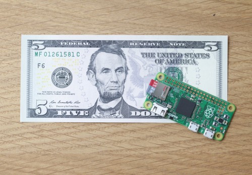
So now I have a lightweight camera on a vibration damping mount that can be triggered by python, I need to get it integrated into the solo. This is the stumbling block, as the Solo wifi network is 10.1.1.1 for the controller and 10.1.1.10. for the drone and the QX100 is 10.0.0.1. As the QX100 is an access point, it needs to be able to connect to the Solo network. That I think is the stumbling block. There was a great post from Jaime Machuca at DIYdrones, where he uses a Intel Edison to "bridge" the data from the solo to the QX. This might be an option. Might be time to splash out a tenner on a new Raspberry Pi Zero!!
 |
An RPi Zero in all its mini-ness. Just needs wifi. |
Not enough posts.
Been a busy week as we head towards Christmas hell. While everyone else seems to be winding down for the holidays, if you are an Antarctic scientist the opposite occurs! We now have less than a month before we ship out for the first season of the DryVER (Dry Valley Environmental Resiliance) project. As its our first year doing the human impact studies on various land surfaces, there is lots of tinkering with our methodology and how we do things.
This morning I've been out at Sumner Beach running though our field sampling methodology. We are trying to quantify the changes in soil compaction and surface disruption when someone walks across a range of land surfaces.
In this photo are three different surface types we are interested in. 1) Above the tape measure is undisturbed sediment, 2) just below the tape is a trail that is the accumulation of me walking over it 20 times and 3) below that are three individual footprints. The white discs are target markers for the high resolution SfM photography I am doing (I've already talked about this technique in a previous post). We are repeating this a number of times within a defined geomorphic unit (i.e. fluvial channel, lake or glacial sediments etc).
If you think that the beach is a crap proxy for Antarctica, heres a photo of the dune field in Victoria Valley!
I'll explain more about the DryVER project this week ( I promise!) and the role that I play in it.
This morning I've been out at Sumner Beach running though our field sampling methodology. We are trying to quantify the changes in soil compaction and surface disruption when someone walks across a range of land surfaces.
 |
In this photo are three different surface types we are interested in. 1) Above the tape measure is undisturbed sediment, 2) just below the tape is a trail that is the accumulation of me walking over it 20 times and 3) below that are three individual footprints. The white discs are target markers for the high resolution SfM photography I am doing (I've already talked about this technique in a previous post). We are repeating this a number of times within a defined geomorphic unit (i.e. fluvial channel, lake or glacial sediments etc).
If you think that the beach is a crap proxy for Antarctica, heres a photo of the dune field in Victoria Valley!
Lower Victoria Valley dune field. Photo by Warren Dickinson. Antarctica New Zealand Pictorial Collections (2015) |
Subscribe to:
Comments (Atom)


